
 AetherONE™AetherGIS™
Geographic information system
Address and location resolution, service areas, spatial and topology versions.
PRODUCT OVERVIEW
Give every meter a versioned spatial context.
AetherGIS is AetherONE’s spatial and location system of record: normalized addresses, location observations, service areas and versioned network topology. Other products consume stable references and spatial projections.
The current evaluation uses deterministic synthetic layers and withholds coordinates. Its maps are design and review surfaces, not grid-control or electrical-calculation tools.
Who it is for
- Location-data stewards
- Network and communication planners
- Enterprise architects and evaluation teams

Responsibilities and evaluation scope
- Address and location resolution
- Approved design scopeNormalized addresses, geocode candidates, competing observations, conflict review and approval state.
- Available in this editionEvaluation interface with synthetic data; no live business operation or persistence.
- Location quality
- Approved design scopeGNSS quality signals and conflicts alongside observations; telemetry remains owned by HES.
- Available in this editionEvaluation interface with synthetic data; no live business operation or persistence.
- Service-point and asset projections
- Approved design scopeSpatial context with lineage/source references; identity remains in CIS.
- Available in this editionEvaluation interface with synthetic data; no live business operation or persistence.
- Network and service areas
- Approved design scopeVersioned electrical/physical network models, historical topology comparison, transformer and feeder service areas.
- Available in this editionEvaluation interface with synthetic data; no live business operation or persistence.
- Communication context
- Approved design scopeVersioned HES communication-topology projection placed in spatial context.
- Available in this editionEvaluation interface with synthetic data; no live business operation or persistence.
- Map governance
- Approved design scopeLayer ownership/visibility, named styles, basemap and PMTiles release metadata, source/licence/provenance registry.
- Available in this editionEvaluation interface with synthetic data; no live business operation or persistence.
- Spatial analytics and quality
- Approved design scopeH3 aggregation intent, quality exceptions/freshness, country-pack conventions and integration health.
- Available in this editionEvaluation interface with synthetic data; no live business operation or persistence.
How the work connects
The original diagrams and interface excerpts below are in English. The surrounding description explains their scope in the page language.
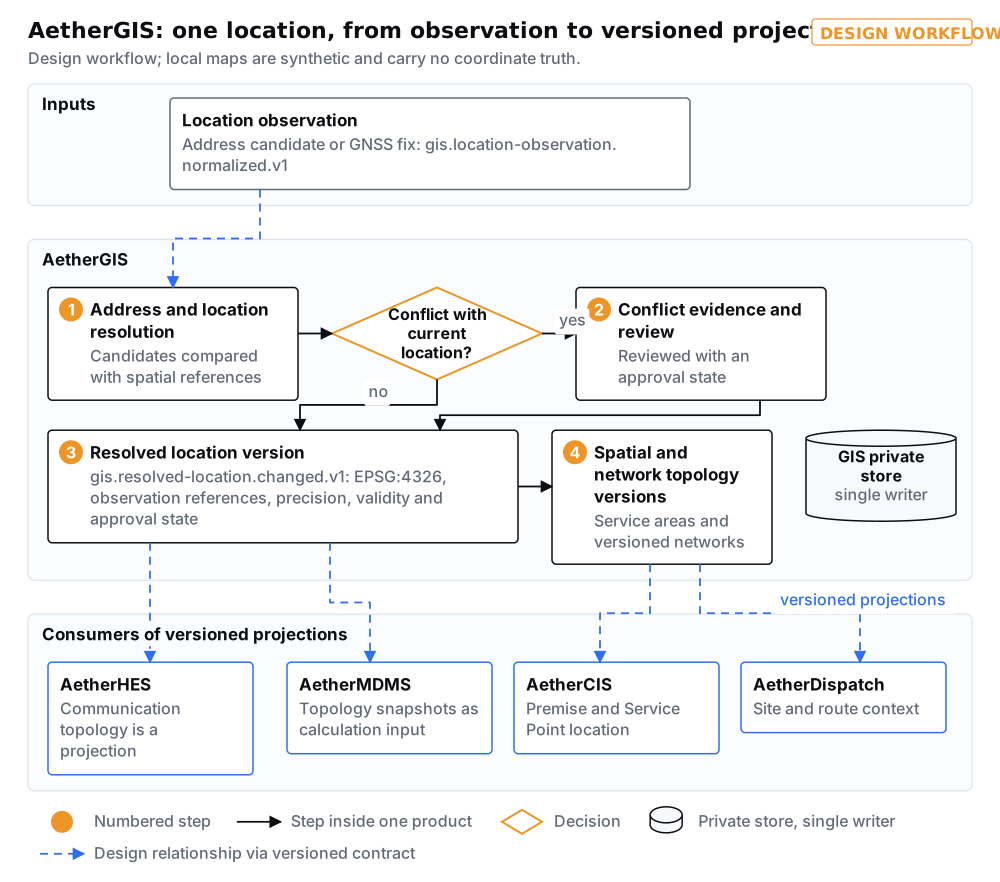
Clear responsibility across products
- AetherCIS / AetherMDMS
- CIS owns service identities. MDMS owns metering context and measurements, and may pin a GIS topology version and hash as calculation input.
- AetherHES / AetherDispatch / AetherRevenue
- HES owns sessions and telemetry; Dispatch owns field execution and consumes site/route context; Revenue owns financial truth. GIS changes none of their private records.
- Location contracts
- Two versioned design contracts describe normalized observations and resolved-location versions with their evidence and approval state. No publisher or consumer runs in this edition; coordinate-system/precision fields are not accuracy guarantees.
Utility scenarios
Reconcile an address and a field fix
Set candidate addresses and competing observations beside their evidence; review conflicts before an effective-dated resolved location is approved in the design.
Compare topology versions
Review meter, transformer and feeder context across network-model versions; calculations in MDMS use their own frozen snapshot reference.
Govern a map source
Review source licences, ownership, visibility, styles and release metadata before a project connects real spatial and map services.
Evaluation views · synthetic data
The original diagrams and interface excerpts below are in English. The surrounding description explains their scope in the page language.
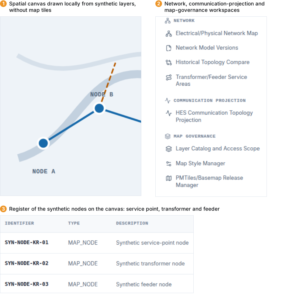
Edition and evaluation conditions
Evaluation interface only: synthetic layers are drawn locally without external map requests. Actions such as candidate ranking, approval or layer publication write nothing. Unknown identifiers show an explicit state instead of substitute data.
GIS/spatial storage, geocoding, tiles/maps, H3 computation, GNSS acquisition, authentication, persistence and completed approvals require project implementation and licensed source data. No accuracy, capacity, OGC conformance, certification or regulatory acceptance is claimed.
The browser evaluation uses React, Vite and TypeScript with a Node.js 24+ toolchain. Korean regulated-postpaid and global postpaid/prepayment profiles are synthetic configurations, not customer references.
Document edition 2026.10 identifies the supplied documents, not a commercial release or a deployed version.
Product documents
Choose a language to download the matching document edition.
- AetherGIS Datasheet · English (PDF)English · PDFDocument edition 2026.10
- AetherGIS Catalogue · English (PDF)English · PDFDocument edition 2026.10